Company Profile
Rainforest Alliance, a New York-based 501(c)3, and UTZ, an Amsterdam-based foundation, merged in 2018. Together, the new Rainforest Alliance is now a $70 million per year organization with offices in 17 countries (and growing) and over 5000 staff. The merged organization has two main offices—one in Amsterdam and one in New York City.
The Rainforest Alliance is creating a more sustainable world by using social and market forces to protect nature and improve the lives of farmers and forest communities.
We work towards making responsible business the new normal through our certification program, tailored supply chain services, landscape and community work and advocacy.
For more information, please visit http://www.rainforest-alliance.org/about.
Job Description
SUMMARY INFORMATION
- Department: Impacts
- Location(s): Sui River, Ghana
- Commitment: 40 days
- Desired start date and duration: 6 October 2025 – 24 November 2025
- Under direction of: Manager, Thriving Landscape M&E
Overview
RA has developed an Impact Framework as part of its 2030 strategy. The Impact Framework takes RA’s mission statement, and the objectives and principles of RA’s 2030 strategy, and answers the question, “How do we measure success?” It describes how RA’s work is expected to deliver its mission through a set of outcomes and impacts. These impacts and outcomes are linked to a set of impact indicators that describe how RA consistently measures progress across various impact areas, from regenerative agriculture, farm economics, human rights to GHG reduction, climate change and forest conversation.
RA is also developing a program called Thriving Landscapes. The Thriving Landscapes are currently five: Selva Maya (Mexico, Guatemala and Belize), San Martin (Perú), North Luwu (Indonesia), Mount Kenya (Kenya) and Sui River (Ghana). In RA-supported Thriving Landscapes, positive impacts for people and nature are cocreated by stakeholders working in alliance towards a shared transformative vision for the landscape. The Thriving Landscapes M&E data collection offers the perfect opportunity and contexts to monitor RA’s impacts over time, across a landscape. These impacts are communicated at landscape and global level through credible evidence, delivering the enabling environment to incentivize further sustainability investments.
RA is therefore seeking an interdisciplinary team of consultants and enumerators to support the execution of the Impact Framework indicators in the Sui River landscape in Ghana, from field data collection to geo spatial data analysis, including data cleaning and aggregation.
Main Objectives
The objectives for this consultancy are as follows:
- Prepare a data collection workplan (locations & schedule, sample population with stratification based on RA data, methodological modification to fit the local context where needed, budgets).
- Attend an (online) inception workshop organized by RA. In this workshop, the RA’s M&E team will train the consultant(s) on the M&E Protocol (indicators, methods & tools, and data deliverables) and other aspects of the assignment.
- Hire enumerators and provide training on data collection of the Impact Framework indicators to the enumerators, based on the M&E Protocol provided by RA
- Execute the data collection in Sui River, Ghana, including:
- A questionnaire survey provided by RA (around 20 questions) for field data. RA will provide the consultant(s) with the names and contact information of around 120 individual farmers to interview, including a backup list of around 30 individuals that can be interviewed if a person on the main list is unavailable. Data collection tool: Kobo Collect. Audio recordings of all surveys must be made.
- Field work (around 120 farm visits) in possibly remote areas including:
- field observations using random plot sampling method for three indicators:
% natural vegetation, # shade trees, # native tree species
- geospatial data collection (GPS coordinates of land cover & farm polygons), following RA prescribed method & tool (Kobo Collect)
- Where necessary, also collect regional data statistics (with clearly defined method, definitions, and data sources) to support the interpretation of the survey data.
- Throughout the assignment, participate in weekly update calls to check progress and address any challenges encountered.
- Provide the final Data products:
- Digital consolidation of all the data collected for RA, including survey answers, geospatial data (GPS coordinates & farm polygons), recordings, and pictures – All data has to be quality checked and cleaned following a data quality control protocol.
- Land cover map at landscape level, between 2016 and 2024 (using Sentinel-2 imagery)
- Land use change analysis at landscape level, between 2016 and 2024
Deliverables
Prior to data collection (estimated duration: 2 weeks)
- Data collection workplan showing the sample population, schedule, maps, etc
- Participation in the online inception workshop organized by RA to align with RA on the M&E protocol and the data collection workplan
- Review methods & test RA prescribed tools used for data collection (Kobo Collect) prior to the training of the enumerators. If required, questionnaire translated into any relevant local languages
- In-person training on data collection to the enumerators, based on the M&E protocol
During data collection (estimated duration: 2-3 weeks)
- Weekly update calls & data sharing to check progress & quality of the data collection and address any challenges, or contextual considerations that are relevant for analysis.
- Provision of authorization/consent forms permitting RA to use of photographs and testimonials, signed by interviewees
Post data collection (estimated duration: 2-3 weeks)
- Excel consolidated database of the survey questionnaire, GPS coordinates, farm polygons and any additional regional statistics, provided data has been quality controlled
- Geospatial data:
- Land cover map (2016-2024) at landscape level following the GHG Protocol’s six land cover classes: Forest, Cropland, Grassland, Wetlands, Settlements, Bare land.
- Land use change analysis (2016-2024) at landscape level (with accuracy metrics of landcover map)
- Complete GPS coordinates for land cover map validation (between 50-75 coordinates per land cover class)
- Complete GPS coordinates for deforestation validation (between 30-50 coordinates)
- Complete farm polygons of at least the largest farm of each respondent (around 120 farms), along with polygons details in shapefile format
- Metadata.
- Photographs of the field visits, file format as requested by RA
- Audio recordings of all surveys.
- An Executive summary including: a brief profile of relevant economic and social characteristics/statistics of Sui River including land use type, main crop and average yield, population and age/gender share, school attendance, deforestation), data collection challenges and recommendations.
- Follow-ups and a final presentation with RA to address any questions regarding the data collected and results obtained.
GENERAL TERMS AND CONDITIONS FOR REQUEST FOR PROPOSAL
- Proposals and/or any additional information received after the submission time and date are subject to rejection by RA. Incomplete proposals may be rejected by RA at its discretion.
- RA reserves the right to request additional information at any time during the procurement process.
- RA is at liberty to make multiple or no selections as part of the proposal process. RA also reserves the right to cancel the procurement.
- All proposal costs shall be borne by the applicant and will not be reimbursed by RA
- The consultant/firm would sign a non-disclosure agreement with RA
- All the materials produced as part of this assignment (e.g. proposal, data, analysis, results) will be of exclusive ownership of RA.
Required Skills or Experience
Academic qualifications (applied to the consultants only)
- Academic Degree in Agronomy, Geomatics (Remote Sensing, Earth Sciences, and GIS), International Development, or related social science and humanities subject required. Equivalent relevant experience combined with a bachelor’s degree may also be considered.
Working experience:
- Demonstrate relevant experience in collecting interdisciplinary data in the field of sustainable agriculture using questionnaire as well as geospatial data (GPS coordinates and farm polygons), field work.
- Have demonstratable experience interviewing rural stakeholders, including women, in a sensible and professional way
- Have good knowledge of the local context of the Sui River landscape (e.g. previous assignments in the same region)
- Have strong working knowledge of Impact indicators in non-profit and corporate sectors, especially relating to international commitments and global sustainability reporting
- Are able to communicate to RA promptly and to address challenges that can hamper the results of the assignment, in agreement with RA.
Other criteria:
- Cost competitive and within budget limitations
- Are eligible to work in the Sui River Landscape, Ghana.
- Have already worked with RA delivering good results is a plus
How To Apply
PROPOSAL PROCESS AND FORMAT
- The proposal should be sent to: ghanaoffice@ra.org; For questions and clarifications, contact Godwin Phylix Cudjoe (Sui River Thriving Landscape Lead)- Email gcudjoe@ra.org - Deadline for submitting proposals: 28 September, 2025
- The proposal should contain:
A technical proposal
- Project team of the consultant firm
- A Cover Letter with a clear understanding of the terms of reference
- A detailed description of the method and data sources to be used for conducting the assignment particularly the land cover map and land use change analysis at landscape level.
- CV identifying the experience and skills related to this offer of the consultant(s).
- Contact details (email and phone numbers) of recent references (2-3)
- All necessary statutory documents such as business registration and value Added Tax certificates.
- An example of previous work (at least 2) that illustrates experience conducting interviews on the topic of farmer experience and applying participatory social science research methodologies
A financial proposal
- Request budget in USD dollar needed to complete deliverables with details for each cost (cost breakdown incl. any payable local taxes). Note: RA prefers not to define budget amount for the opportunity. Instead, we prefer to gather proposals to determine market price for activity. Stating the budget available for the consultancy can result in proposals only coming back at that cost. The tenderer shall indicate, in full and in figures, in its tender the total amount as shown in the estimate. In the event of a discrepancy between the amount expressed in letters and the amount in figures, the minimum amount will prevail. All documents submitted by the tenderer, for any reason whatsoever, pursuant to this restricted consultation, will be drawn up exclusively
- This call for proposals is subject to the duties and taxes payable in Ghana.
The Rainforest Alliance reserves the right to verify, by any means, the information provided by the Bidder. Any inaccuracy in the information given will automatically result in the rejection of the corresponding offer.
GLOSSARY
Land cover map: The physical and biological cover over the land surface, including water, vegetation, bare soil, and artificial structures (source: ESRI)
Land cover classification: the process of categorizing the types of surfaces and vegetation covering the Earth's land surface based on remotely sensed imagery or other spatial data (source: Caliper).
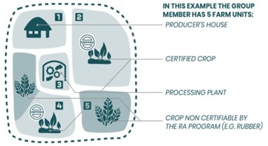
Farm: All land and facilities used for agricultural production and processing activities (source: Rainforest Alliance). Below is an example of a farm that includes 5 different farm units:
Farm’s geolocation data: Data that identifies the geographic location and boundaries of the farms of the farmers. Geolocation data is represented by coordinates generally collected through Geo Positioning Systems (GPS) mapping using either individual location points or polygons which define the full boundaries of the relevant area (source: Rainforest Alliance).
Note
Please note, employers receive numerous applications per posting and will only shortlist the most qualified candidates. Also
Jobsinghana.com is not involved in any decision made by an employer/recruiter and therefore does not guarantee that applications sent
will result in a candidate being shortlisted/selected for that position.
|